-

- いいね!665
 𝒖𝒔𝒂𝒎☣
@usamR
𝒖𝒔𝒂𝒎☣
@usamR
北京のIBM製メインフレームがハックされて流出したウイグル・カザフ人強制連行現場ドローン空撮オリジナル動画 "新疆 : 新讲 Xinjiang : a New Explanation" を YouTube で見る youtu.be/gGYoeJ5U7cQ
2019-10-08 19:32:08
War on Fear
@warcombatfear
The people of today's society always live under the supervision of the government with high technology. Now we use technology to show the modern society of Xinjiang. People lose their freedom. No hope for future. How many people in prison? @Reuters @AP @amnesty @UNHumanRights pic.twitter.com/8hljD719sc
2019-09-18 03:43:16
Nathan Ruser
@Nrg8000
4 days ago a video showing 3-400 detainees handcuffed & blindfolded at a train station in Xinjiang was uploaded to YouTube (youtube.com/watch?v=gGYoeJ…) In this thread I'll share how I've verified that this video was filmed at 库尔勒西站 (41.8202, 86.0176) on or around August 18th. pic.twitter.com/hr5xd8nahM
2019-09-21 19:17:44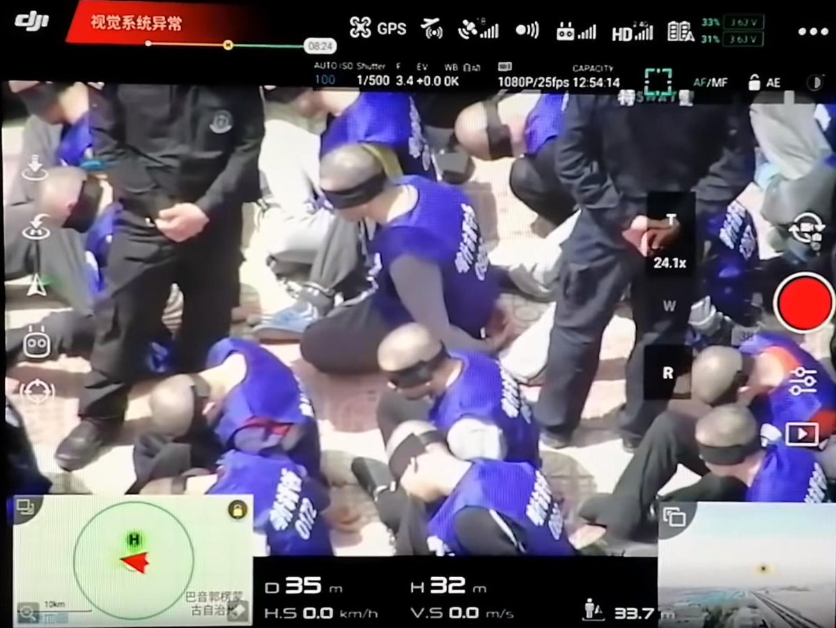 拡大
Nathan Ruser
@Nrg8000
拡大
Nathan Ruser
@Nrg8000
Firstly, let's look at the video. It shows a screen recording of a dji drone which has captured hundreds of detainees (presumably Uyghurs) being led off of a train, and lined up - freshly shaven, blindfolded and handcuffed - at a train station. pic.twitter.com/wdlj8FAjGW
2019-09-21 19:21:31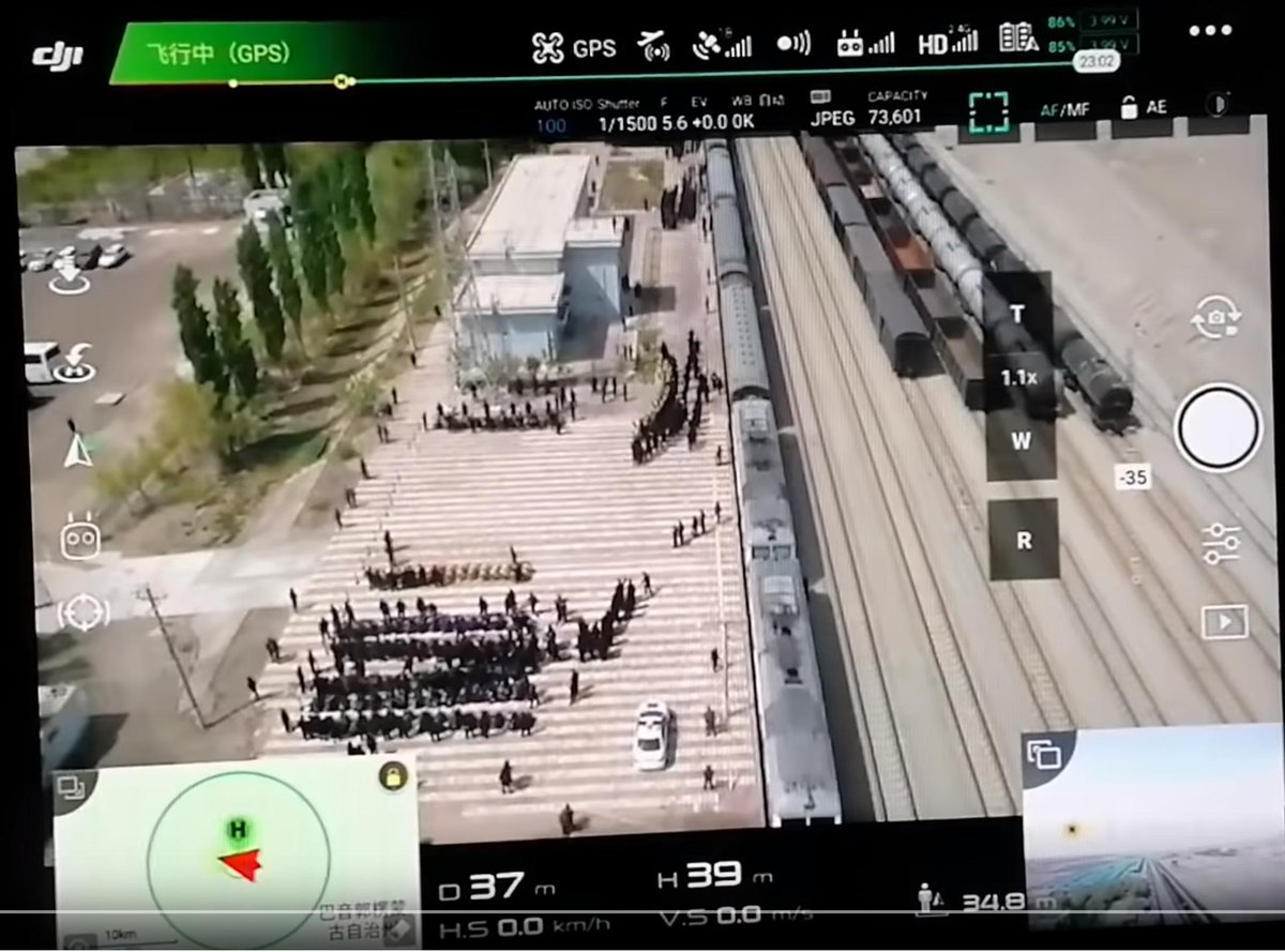 拡大
Nathan Ruser
@Nrg8000
拡大
Nathan Ruser
@Nrg8000
In terms of information to verify this video, it is quite scant. The title mentions that it shows something in Xinjiang, and the description says that it was 'taken in China' - "这些视频是在中国拍的", which is not a lot to work with.
2019-09-21 19:23:00
Nathan Ruser
@Nrg8000
Moreover, this is the only video uploaded to a new account, but let's look at what there is available for us to geolocate: building, cell-tower, blue buildings, carpark, trees, train tracks ect. pic.twitter.com/2smcvvrqcD
2019-09-21 19:26:46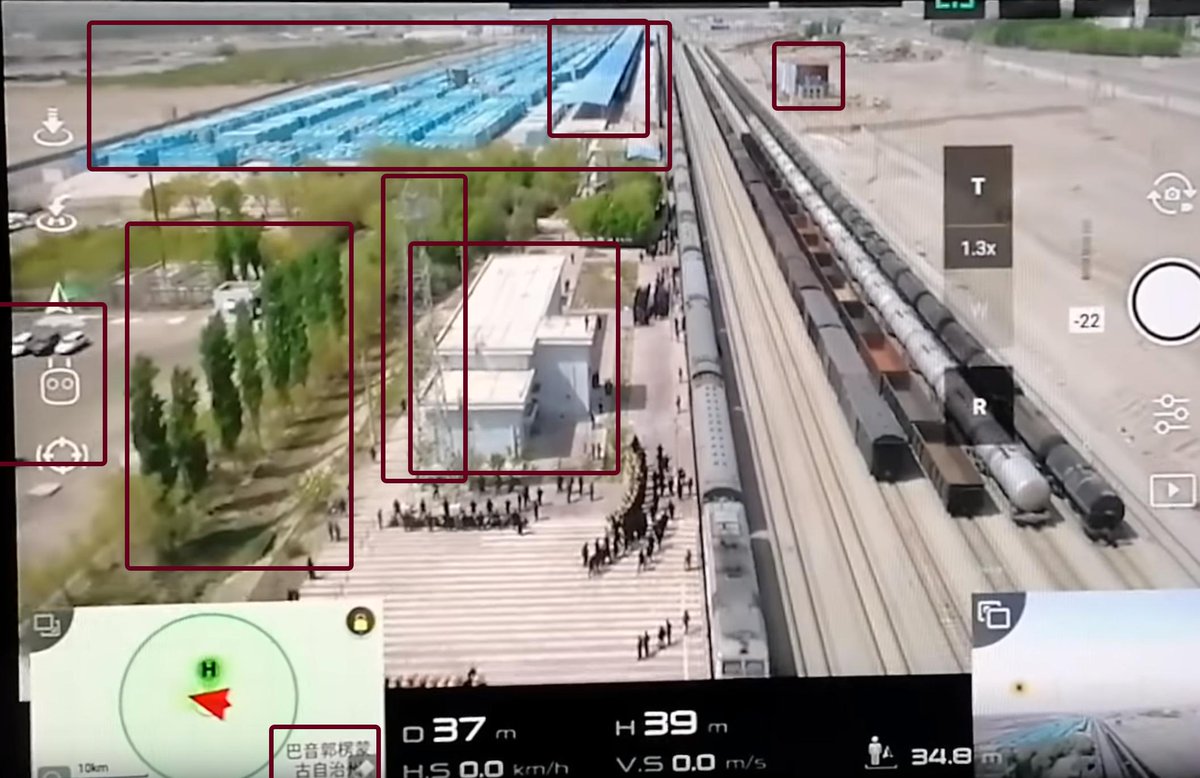 拡大
Nathan Ruser
@Nrg8000
拡大
Nathan Ruser
@Nrg8000
The biggest clue is the orientation map in the bottom left that says (after a bit of squinting & checking Baidu Maps) "巴音郭楞蒙 古自治州", an autonomous prefecture in Xinjiang that is often largely synonymous with the city of Korla. This was clearly filmed to the NW of there.
2019-09-21 19:28:31
Nathan Ruser
@Nrg8000
The drone's FPV camera is also pointing almost straight down the train tracks, which shows the orientation of the tracks at about 282° if you measure it. This narrows down the section of train tracks that it could potentially be. pic.twitter.com/DETYA0Fuh6
2019-09-21 19:35:07 拡大
Nathan Ruser
@Nrg8000
拡大
Nathan Ruser
@Nrg8000
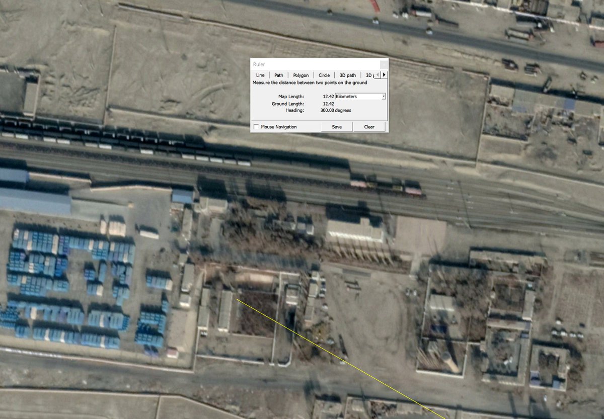
The bigger clue lies in the 10km scale bar in the bottom left, which (on my screenshot) represents 6.48cm. The distance from the approx centre of Bayingol label to the location is 8.05cm (at a bearing of ~ 300°) (8.05/6.48)*10 = 12.42km at a bearing of 300° from the label.
2019-09-21 19:41:30
Nathan Ruser
@Nrg8000
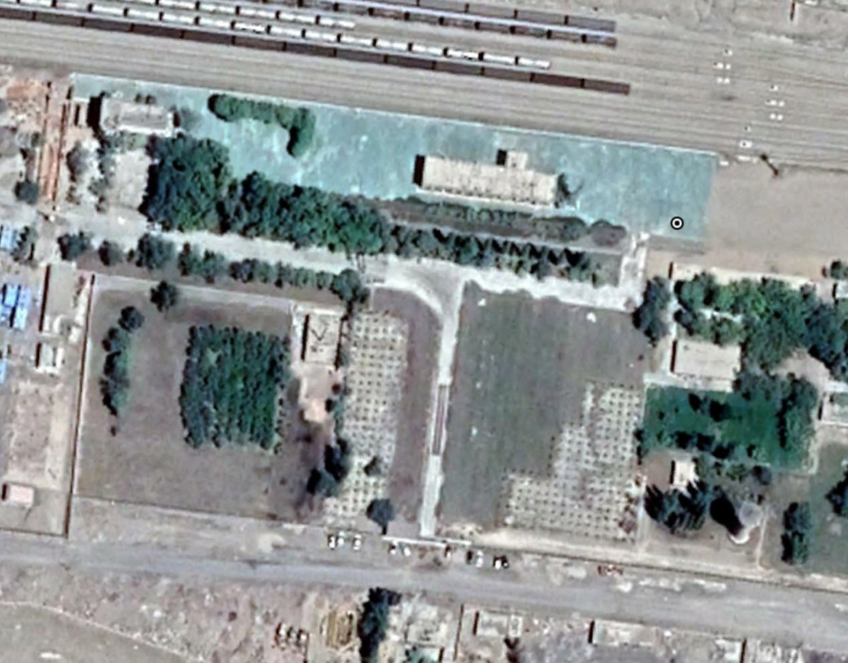
Feeding that into Google Earth gets you pretty bang on. You can see the building, the trees, the tracks, the car-park (which was in the process of being paved in the June 17th 2019 satellite image - important later!) pic.twitter.com/LN2Jjr7hO0
2019-09-21 19:55:56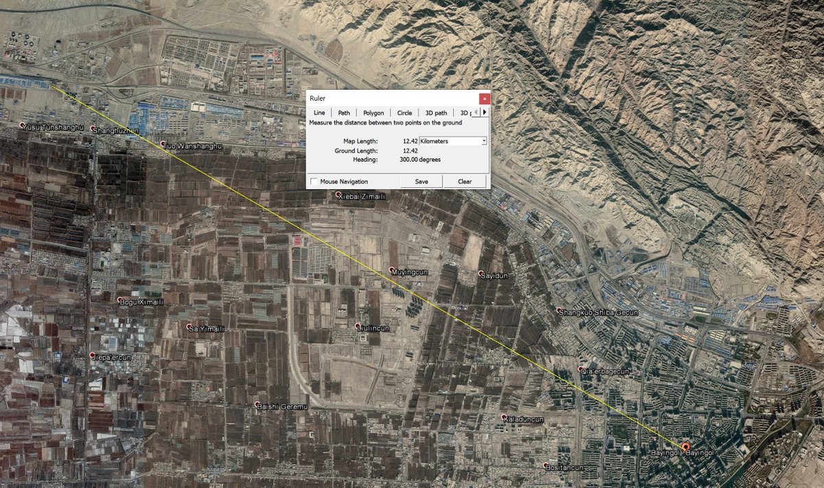 拡大
拡大
 拡大
Nathan Ruser
@Nrg8000
拡大
Nathan Ruser
@Nrg8000
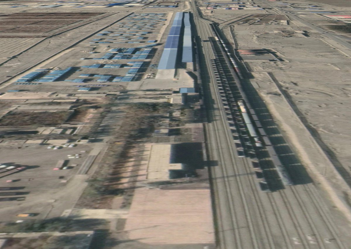
Indeed, just look at this. It's pretty clear where this video was taken (also just want to shout out to the Chinese script were the exact point of the label could be determined because each character is a square). pic.twitter.com/9SepNTNZWd
2019-09-21 20:00:15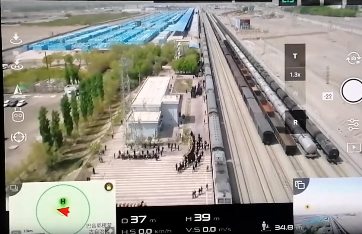 拡大
拡大
 拡大
Nathan Ruser
@Nrg8000
拡大
Nathan Ruser
@Nrg8000
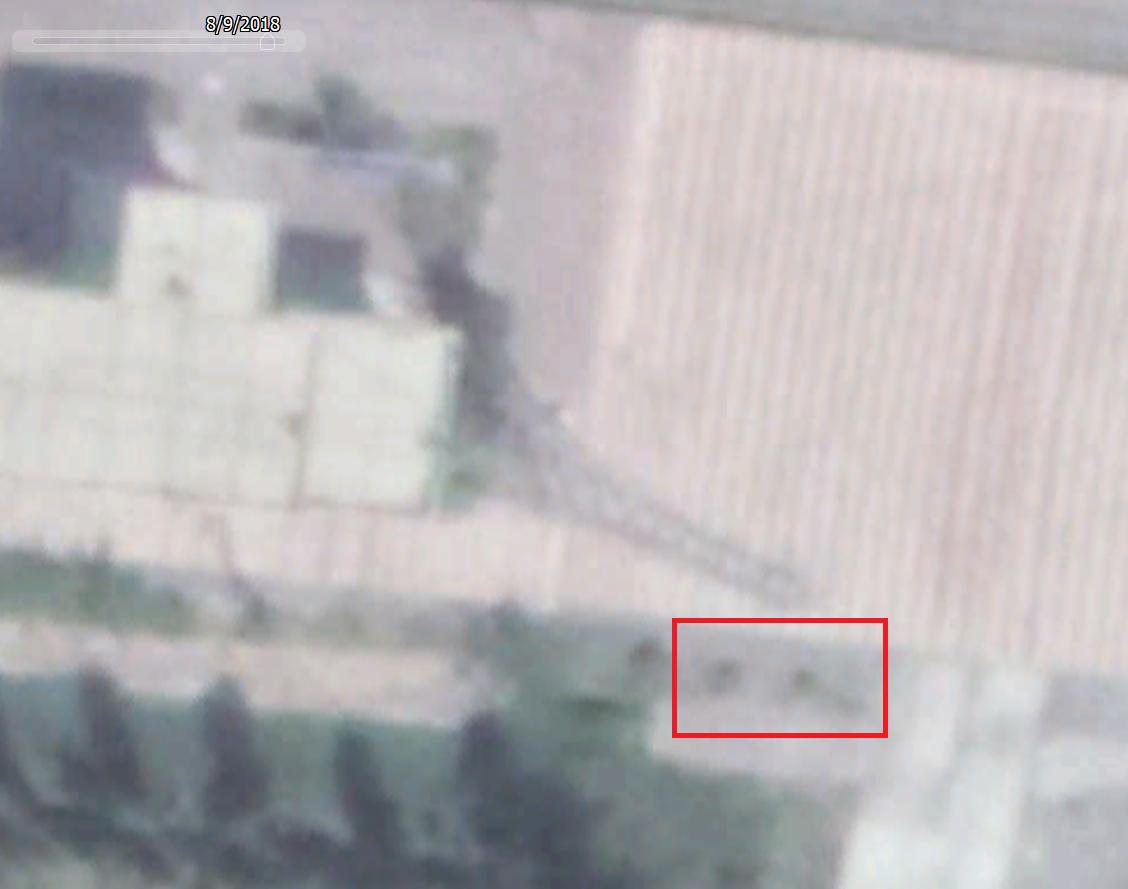
Now, to work out when this video was taken. Luckily the world is full of little sundials. See this telegraph pole. It casts a shadow which is conveniently clear, ending about 8 white lines away from the pavement, and in line with (or ~ a foot past) where the stripes get shorter. pic.twitter.com/yM37Yf2Tii
2019-09-21 20:03:30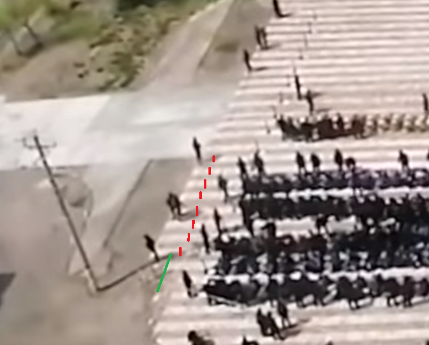 拡大
Nathan Ruser
@Nrg8000
拡大
Nathan Ruser
@Nrg8000
This puts the shadow's end at about exactly this position. The image in Google's collection where the shadow looks the closest is taken on 7th Sept 2019. Regardless we can show that the shadow is approx 5m long with a sun azimuth of 173.38°. This are all very approximate. pic.twitter.com/iG7XbAMmD2
2019-09-21 20:09:25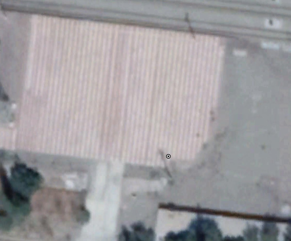 拡大
Nathan Ruser
@Nrg8000
拡大
Nathan Ruser
@Nrg8000
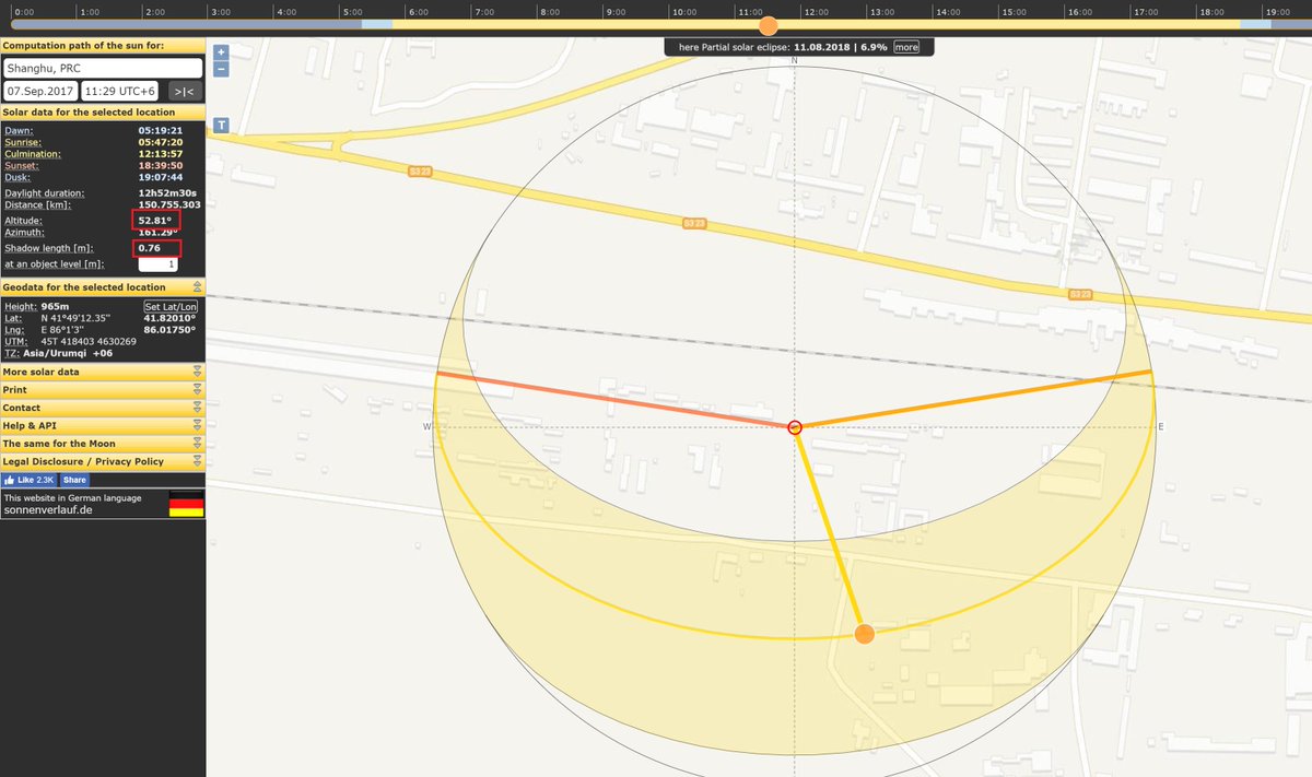
Now to reverse engineer how tall the pole is. The Google imagery shows a the pole's shadow at ~6.75m long. Looking in Digital Globe's catalogue we can also see the sun elevation was 52.8°. Feeding that into SunCalc we see that at that time an object 1m tall casts a 0.76m shadow. pic.twitter.com/vLMooTX6BE
2019-09-21 20:14:57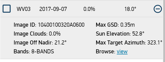 拡大
拡大
 拡大
Nathan Ruser
@Nrg8000
拡大
Nathan Ruser
@Nrg8000
6.75*(1/0.76) = 8.88 Therefore we know that the pole is ~8.88m tall. All we have to do to find an approximate date is play around with SunCalc (suncalc.org) and find the time/day where an 8.88m object casts a 5m shadow with a sun azimuth of 173.4° 12:06pm, Aug 20th pic.twitter.com/4WRgBXZenC
2019-09-21 20:21:41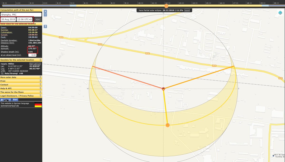 拡大
Nathan Ruser
@Nrg8000
拡大
Nathan Ruser
@Nrg8000
These figures are approximate! You'll notice it changed from August 18th to August 20th, that's because when I re-did it for this thread it must have been measured differently by a few feet or degrees. This is impossible to avoid when youre measuring so fine with less detail.
2019-09-21 20:23:21
Nathan Ruser
@Nrg8000
The year is a trickier thing to determine, which has to be done through chronolocating the video with satellite imagery - matching and picking the difference between the video and various satellite images. In this video the carpark is not paved. It was being paved in June 2019. pic.twitter.com/VaZnrVqYaG
2019-09-21 20:33:28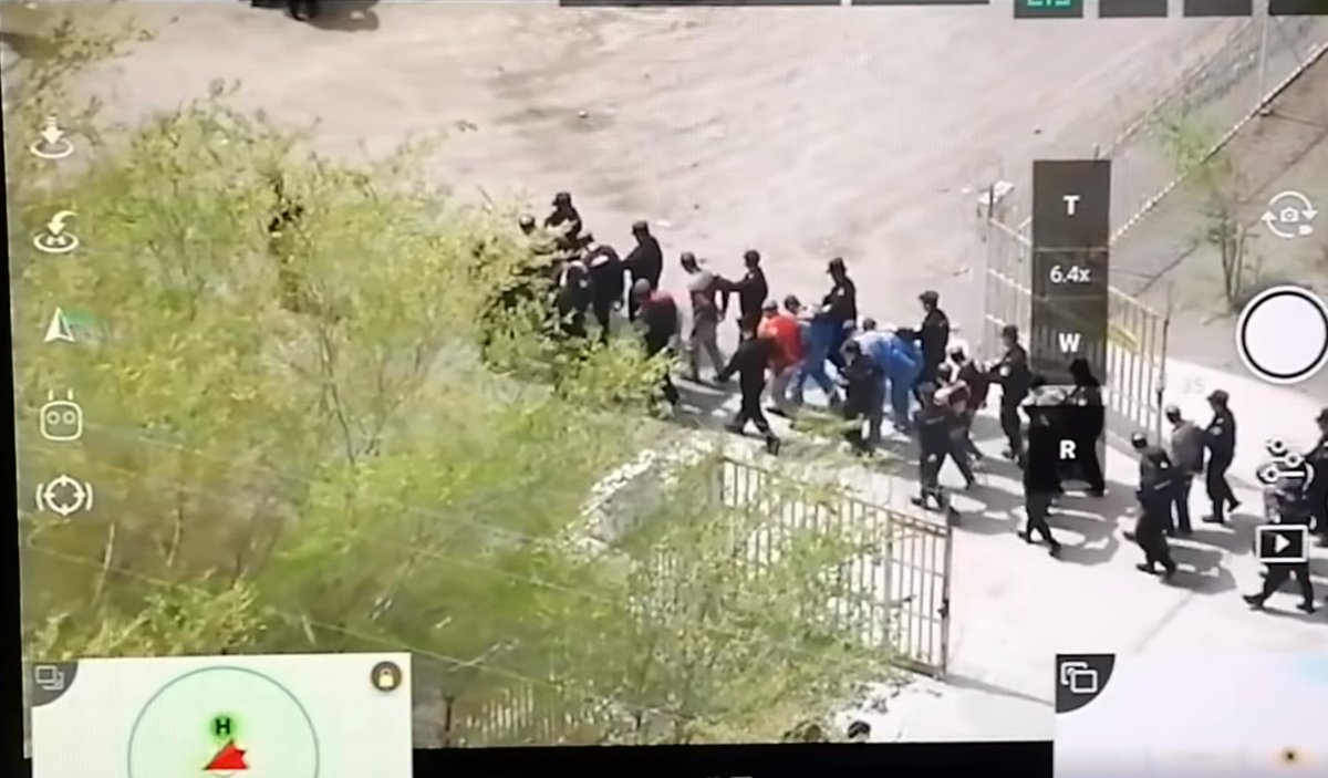 拡大
拡大
 拡大
Nathan Ruser
@Nrg8000
拡大
Nathan Ruser
@Nrg8000
This rules out August 20th 2019 as the date of the video (also the red-and-white stripey path was repaved green for some reason - it's remained green, not just covered for the nearby paving). The crackdown started 2017, so with context it is either Aug 2017 or 2018.
2019-09-21 20:36:12
Nathan Ruser
@Nrg8000
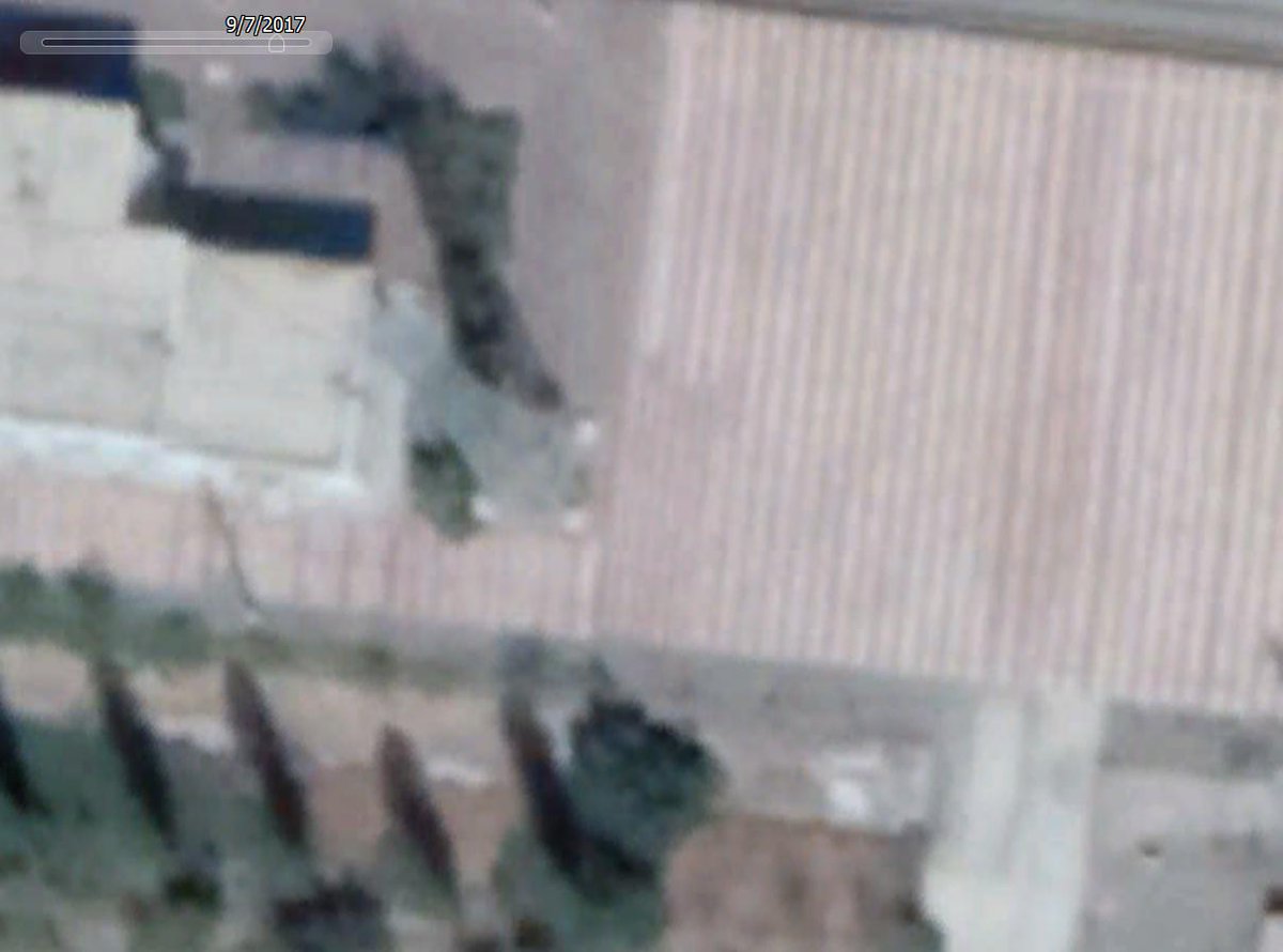
There aren't a lot of further clues, but the world does always change! So the best I could find are these two small bottom most bushes. In 2017 they weren't there. In 2018 they were. Therefore we can tell this video was filmed on/around August 20th 2018. pic.twitter.com/SMZ7ufopyA
2019-09-21 20:39:30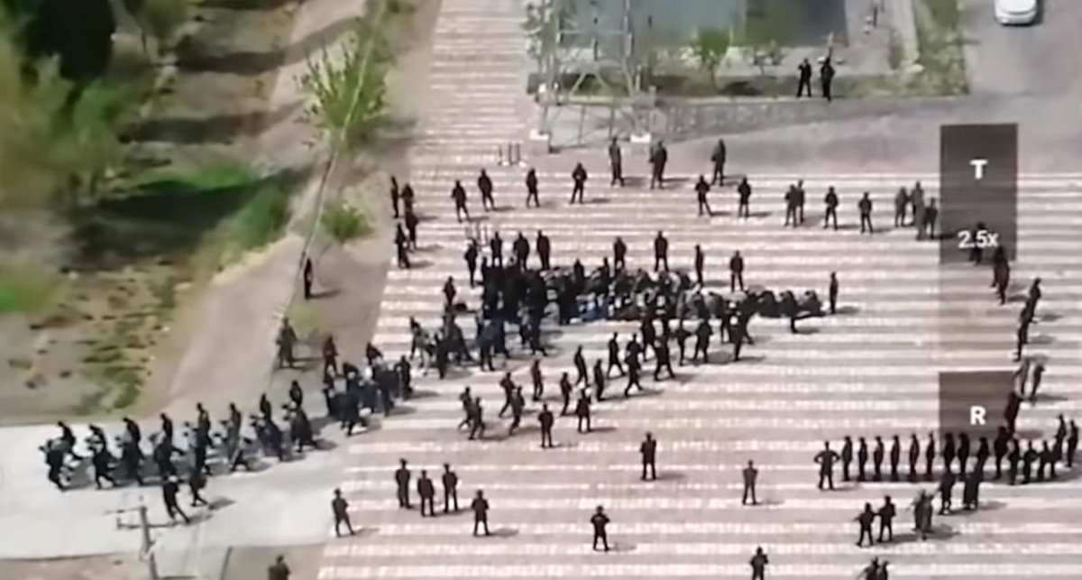 拡大
拡大
 拡大
拡大
 拡大
Nathan Ruser
@Nrg8000
拡大
Nathan Ruser
@Nrg8000
But essentially this thread offers some techniques to verify imagery that I hope you find helpful. By verifying it, you can essentially prove that it is real and true, that what you're seeing did occur, and that it's location and date is known with enough detail to make it useful
2019-09-21 20:43:49
Nathan Ruser
@Nrg8000
International warrants have been granted to prosecutors on the basis of social media videos which have been verified in such a manner. bellingcat.com/news/mena/2017… It also fact checks the video, so that media organisations can be comfortable sharing it to their audiences.
2019-09-21 20:45:54
Nathan Ruser
@Nrg8000
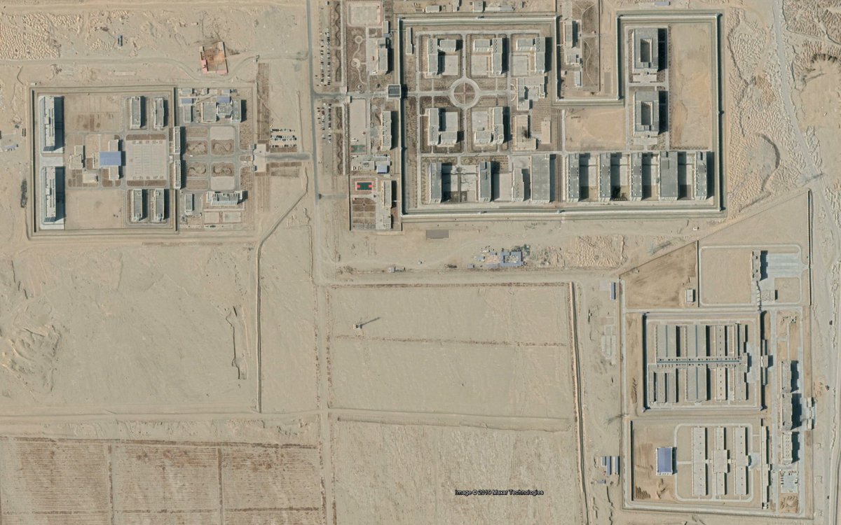
@hongkongharv They're likely being transferred to a nearby camp/prison complex. I've done work previously implicating this camp in coerced labor for Western companies such as @CottonOn. aspistrategist.org.au/what-satellite… pic.twitter.com/YYVTXvZM0u
2019-09-21 21:34:54 拡大
拡大
 拡大
拡大
 拡大
𝒖𝒔𝒂𝒎☣
@usamR
拡大
𝒖𝒔𝒂𝒎☣
@usamR
コルラ西駅(Googleマップではその駅名では検索できない)で丸坊主にされ手錠目隠しをされ強制連行される数百人のウイグル人。ネイサン氏の分析によると2018年8月20日にドローンで撮影されたものらしい twitter.com/Nrg8000/status…
2019-09-21 22:38:10
𝒖𝒔𝒂𝒎☣
@usamR
私もすぐにOSINTしてみたのだが、当然ネイサン氏のほうが詳細に分析しているので詳しくは彼のツイートを追ってみて欲しい(英語だけどナー)。このスレッドでは自分なりのOSINT(オープンソースインテリジェンス)を。ネイサン氏が直ぐに連ツイしていたので単なるオナニーにしかなりませんがねw pic.twitter.com/nMd2lPXrhb
2019-09-21 22:46:27 拡大
𝒖𝒔𝒂𝒎☣
@usamR
拡大
𝒖𝒔𝒂𝒎☣
@usamR
こんな動画見せられたらそりゃもう真偽を確かめたくなりますよねえ。この人達はどーみても漢人には見えない。見張りの背中には「特SWAT警」の文字が。対テロ特殊部隊じゃないですか!こりゃ多くのウイグル人が鉄道で強制連行されてきて強制収容所に収監される現場の動かぬ証拠ではないかっ! pic.twitter.com/0WTWemFfeK
2019-09-21 23:03:03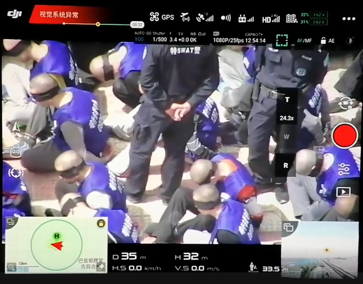 拡大
拡大